


History
This site was home to one of Lockheed Martin acquisition companies that had satellite development and manufacturing operations from 1957 to 1998.
- The most notable products are the first weather satellite; and communications equipment for the first American space communications satellite.
- The site consisted of 127-acres at the intersection of Edinburg Road (Route 535) and Millstone Road.
- In 1995 the site was closed after the merger of Lockheed and Martin Marietta. Lockheed Martin consolidated this business with its satellite operations in Sunnyvale, California.
- In 1998 the site was sold in two parcels.
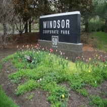
- The property is currently used for offices and laboratories; a portion of the site remains undeveloped. Raith Capital, LLC later acquired the developed portion of the property.
- The 11-acre parcel south of Route 535 was sold to Blacklight Power.
Discovery
In 1989, during removal of underground storage tanks, contaminants were discovered in the site groundwater:
- Contaminants discovered: trichloroethylene (TCE) and other chlorinated volatile organic compounds (CVOCs) used commonly as industrial solvents, as well as common natural breakdown products of CVOCs; aerosol propellant; refrigerants.
- Areas where contaminants exceeded New Jersey groundwater quality standards were sporadic and localized, except for TCE. Concentrations of TCE were also found in groundwater off site.
- No water supply wells were at risk. TCE vapor intrusion was also not a risk.
Cleanup
After the contaminant discovery, the New Jersey Department of Environmental Protection (NJDEP) declared that the site required cleanup.
- The department’s investigation continued into the 1990s. To clean the groundwater, Lockheed Martin and its contractors:
- Evaluated cleanup alternatives
- Extracted and treated groundwater
- Implemented techniques to enhance the natural biological breakdown of the chlorinated volatile organic compounds
- The NJDEP directed all work, including cleanup of contaminated soil.
2010
Based on evidence from monitoring wells that concentrations of contaminants were declining, the groundwater extraction and treatment system was shut down to determine if natural breakdown would be sufficient to reduce remaining contaminants.
- Samples collected over the next few years showed that remaining contaminants were degrading naturally.
- This confirmed that natural breakdown could complete the cleanup.
2015
A Remedial Investigation Report detailing the results was submitted to the NJDEP recommending continued groundwater monitoring.
2016
A Groundwater Classification Exception Area (CEA) application was submitted to the New Jersey Department of Environmental Protection (NJDEP).
- The CEA states: the public will be notified every two years of any remaining groundwater contamination.
- The CEA also requested the NJDEP restrict installation of drinking water wells within the Exception Area. The department implemented the restriction.
- At the appropriate time, and with NJDEP approval, the site will be closed.
- Lockheed Martin will document and publish all studies, results and conclusions in accordance with NJDEP regulations and requirements.
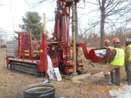
Spring 2015 - Six deep monitoring wells were installed to definitively establish the depth at which groundwater is impacted.
Groundwater Monitoring
- Six additional monitoring wells were installed onsite in spring 2015 to understand any remaining impact on the groundwater.(see pictures to the right)
- Groundwater is monitored regularly through these wells on both the 116-acre site north of Old Trenton Road, (Route 535), and the 11-acre Blacklight Power property south of the road.
- These wells dot the parking lot of the main building north of Old Trenton Road.(see picture top)
- They are sampled quarterly to evaluate the extent contaminants in the groundwater have degraded.
- View the Annual Groundwater Monitoring & Inspection Summary Report & Field Activity Memo 2021
View a List of Terms Commonly Used in Relation to General Environmental Remediation Efforts
Community Information
If you have questions, please contact Lockheed Martin Communications.
lm.communications@lmco.com
800.449.4486
View the East Windsor Document Archive
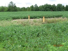
This deep monitoring well is located on the southern portion of the 11-acre Blacklight Power property, towards Route 133, the Hightstown By-pass.
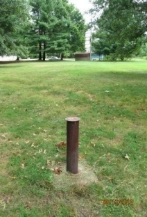
This monitoring well is located on the eastern side of the main property.
These monitoring wells are located in the southern portion of the 11-acre Blacklight Power property, towards the Hightstown By-pass.
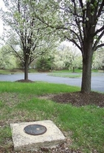
Much of the main property remains undeveloped. These monitoring wells are located in the far northern portion of the property.
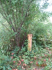
Much of the main property remains undeveloped. These monitoring wells are located in the far northern portion of the property.